Vidéo 42km du Mont-Blanc 2015 from Marathon du Mont-Blanc on Vimeo.
Race description
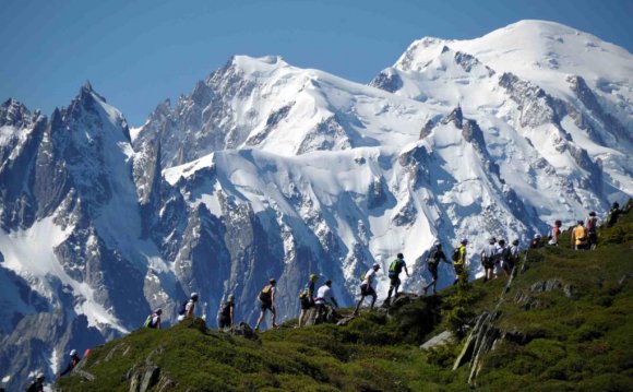
Starting from the centre of Chamonix (1035m) the route climbs steadily towards the upper valley, progressively passing through the hamlets of "les Bois" and Lavancher to reach Argentière (1250m).
Runners will bypass the village of Argentière and reach Le Planet by the "Chemin des Rambles" before going to Montroc using a local road, closed for the event. After going through the village of Montroc you take the trail towards Tré le Champ and from here, you go towards the Col des Montets.
The route crosses the "Col des Montets" (1461m) in the heart of the Aiguilles Rouges' Natural Reserve. Then along the "chemin des Diligences", the old stage-coach route, you arrive at the hamlet of Buet before reaching Vallorcine (1260 m), nestled at the bottom of a pretty valley at just a stone's throw from Switzerland. Here begins the progression to the Col des Possettes (1997m) via a trail leaving from the Plan de l'envers.A refreshment post is available at the top of the col before finally climbing up to the Aiguilles des Posettes (2201m) where you will be rewarded by a breathtaking panoroma of the Mont Blanc range.
Facing the ‘Aiguille Verte' and the Mont Blanc range, the route follows the ridgeline of the 'aiguillette' gradually descending in the direction of Tré le Champ. You will go along a pretty trail that brings your toward le Tour, crosses through the village, and then takes you near to the Tour glacier. Then, you will take a north facing trail (a cooler perspective.) towards Montroc before crossing through the hamlets of the Frasserands and Tré le Champ.
At the heart of the Aiguilles Rouges massif, at the opposite of the Mont-Blanc range, the route climbs up towards la Flégère (1875 m). After crossing the magnificent Charlanon comb(1812m) the climb is gentle on a balcony path, with one of the most beautiful views of the Mont-Blanc, to reach Altitude 2000.
Download the race map below
The organisation has decided to use the distances and vertical gain/lost estimated by the International Trail Running Association (ITRA, association of which it's a member), for the Mont-Blanc 80km and 42km. The organisation also insists on the fact that, according to the software used and the adjustments, the gpx files may have very different results (a vertical gain from 2407m to 3192m for the 42km).
|
Official distance |
Vertical gain estimation according to the adjustments | Route
Yellow = initial route Red = fallback path |
Profile | Time | GPX file
Right clic Save as |
|
| Low estimation
(threshold 30m) on visu GPX |
High estimation
(without thresold) on visu GPX |
|||||
| 42km
2730m D+ 1700m D- |
2407m+ | 3192m+ |  |
|||
Race bib distribution
To get their bibs on the 42km, runners will have to show their race bag with all their mandatory equipment to be checked. It will also allow the organisation to put a chronometric chip. No bib will be given to runners who don't have their equipment controlled.No bib will be given less than 30 minutes before the race start.
Obligatory material :
- Mobile phone.
- Stock of water minimum 0, 50 liter.
- Waterproof jacquet windproof.
- Whistle.
- Survival blanket.
- Personnal cup
YOU MIGHT ALSO LIKE


Share this Post
latest post
-
 Chamonix Massage May 21, 2026
 -
 6 days Snow forecast May 1, 2026
 -
 Ski resorts Near Chamonix April 11, 2026
 -
 Chamonix Shuttles March 22, 2026
 -
 Chamonix resort March 2, 2026
 -
 Ice climbing Chamonix February 10, 2026
 -
 Tourists in Chamonix January 21, 2026
 -
 Snowfall in Chamonix January 1, 2026
 -
 Visit Chamonix December 12, 2025